wisemonkeys logo
FeedNotificationProfileManage Forms
FeedNotificationSearchSign in
wisemonkeys logo

Blogs

geographic information system (GIS)

profile
Ameya Gawade
Mar 16, 2023
0 Likes
0 Discussions
214 Reads

A geographic information system (GIS) consists of integrated computer hardware and software that store, manage, analyze, edit, output, and visualize geographic data.[1][2] Much of this often happens within a spatial database, however, this is not essential to meet the definition of a GIS.[1] In a broader sense, one may consider such a system also to include human users and support staff, procedures and workflows, the body of knowledge of relevant concepts and methods, and institutional organizations.

The uncounted plural, geographic information systems, also abbreviated GIS, is the most common term for the industry and profession concerned with these systems. It is roughly synonymous with geoinformatics and part of the broader geospatial field, which also includes GPS, remote sensing, etc. Geographic information science, the academic discipline that studies these systems and their underlying geographic principles, may also be abbreviated as GIS, but the unambiguous GIScience is more common.[3] GIScience is often considered a subdiscipline of geography within the branch of technical geography.

History and development

While digital GIS dates to the mid-1960s, when Roger Tomlinson first coined the phrase "geographic information system",[5] many of the geographic concepts and methods that GIS automates date back decades earlier.

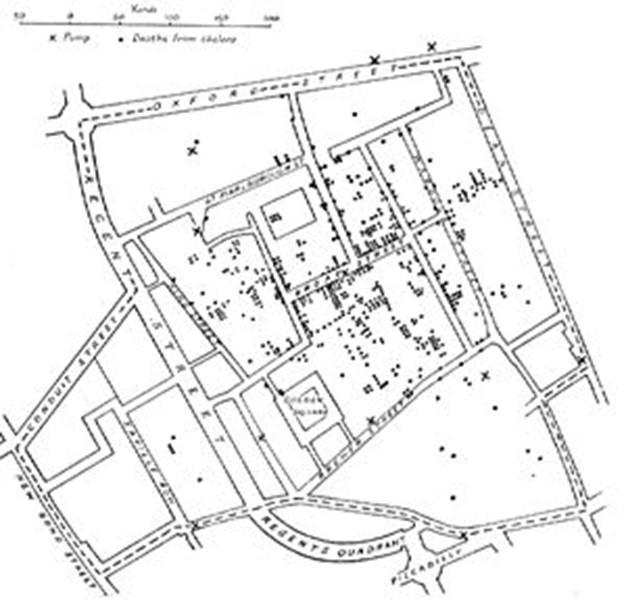
One of the first known instances in which spatial analysis was used came from the field of epidemiology in the "Rapport sur la marche et les effets du choléra dans Paris et le département de la Seine" (1832).[6] French geographer and cartographer, Charles Picquet created a map outlining the forty-eight Districts in Paris, using halftone color gradients, to provide a visual representation for the number of reported deaths due to cholera per every 1,000 inhabitants.


Comments ()


Sign in

Read Next

Threads

Blog banner

OS Assignment 3 Deadlock

Blog banner

Domain Name System

Blog banner

Threat management

Blog banner

Nature’s Brush on Silk: The Secret Behind Patola Colours

Blog banner

Street foods

Blog banner

INTERRUPTS

Blog banner

Memory Management

Blog banner

The Benefits of Practical Life Activities in Preschool

Blog banner

Elegant fashion style

Blog banner

Importance Of Time

Blog banner

JIRA SOFTWARE

Blog banner

MODERN OPERATING SYSTEMS

Blog banner

Method of Evaluating Information Security Level in an Organization

Blog banner

Race Condition in Operating Theatre

Blog banner

Memory Management - operating system

Blog banner

GIS Bharat Maps

Blog banner

Blockchain

Blog banner

Data Science in Predictive Analytics: Transforming Business Decision-Making

Blog banner

E-commerce

Blog banner

Modern Operating System

Blog banner

Data Exfiltration

Blog banner

PYTHON

Blog banner

Importance of Website

Blog banner

Vulnerabilities in OnePlus Devices

Blog banner

"Geographic Information Systems (GIS) and its Applications in Urban Planning"

Blog banner

MENDELEY

Blog banner

Short note on expert system

Blog banner

Defining youtubr

Blog banner

Security Issues and Countermeasures

Blog banner

Tracking Emails & Email Crimes

Blog banner

Buffer Overflow

Blog banner

To-Do List In LISP

Blog banner

MySQL

Blog banner

Why Time Management Is the Secret to College Success (and How to Master It)

Blog banner

Virtual memory

Blog banner

DNS Cache

Blog banner

Cloud Security: Trends and Innovations

Blog banner

?What Children Learn Between Activities: The Hidden Learning Moments in a Preschool Day

Blog banner

How Harshad Valia International School is nurturing India’s Young Minds?

Blog banner

John Titor: The Time Traveler

Blog banner

Banaras

Blog banner