GIS technology has many applications in oceanography, including the study of ocean currents, tides, waves, and other oceanographic phenomena. GIS can be used to analyze and display oceanographic data, such as bathymetry (ocean floor topography), water temperature, salinity, and chlorophyll concentrations. This data can be used to create maps and visualizations that help scientists understand ocean processes and how they are affected by factors such as climate change and human activities.
One example of an ocean application of GIS is in coastal zone management. GIS can be used to analyze coastal erosion, map the distribution of wetlands and other important habitats, and predict the effects of sea level rise on coastal communities.
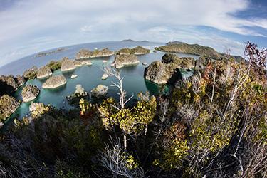
How does coastal zone management work with help of GIS
Coastal zone management (CZM) uses GIS technology to analyze and manage the complex interactions between the physical, biological, and human systems that make up the coastal zone. GIS can be used to map and analyze various types of data, including bathymetry, shoreline change, land use, land cover, population density, and many other factors. This information is used to understand the coastal zone, identify problems, and develop solutions.
One of the key ways that GIS is used in CZM is to map and analyze coastal hazards, such as flooding, erosion, and storm surge. GIS can be used to create detailed maps of the coastal zone, including the location of critical infrastructure, such as roads, buildings, and utility lines, that are at risk from these hazards. This information can be used to identify areas that are most vulnerable to coastal hazards and to develop plans to reduce the risk of damage.
Another important use of GIS in CZM is to map and analyze the distribution of important coastal habitats, such as wetlands, dunes, and coral reefs. GIS can be used to create detailed maps of these habitats, including information on their size, shape, and condition. This information can be used to identify habitats that are most at risk and to develop plans to protect and restore them.
Additionally, GIS can be used to monitor and analyze the effects of human activities on the coastal zone. This includes the effects of development, pollution, and other human impacts on coastal habitats, water quality, and other environmental factors. GIS can also be used to analyze the economic, social, and cultural aspects of coastal communities and to identify the issues that are most important to them.
Overall, GIS plays a vital role in coastal zone management by providing the data and tools necessary to understand and manage the complex systems that make up the coastal zone.
Another example is in marine protected areas management, GIS can be used to map and identify important habitats, such as coral reefs, and to monitor the effects of human activities on these habitats.
Additionally, GIS can be used in marine navigation and shipping, to help ships navigate safely, and to help to prevent ship-to-ship collisions, groundings, and other accidents.