
Geographic Information Systems (GIS) have become increasingly popular in the agriculture and farming industry, providing valuable insights into land use and resource management. Here are some key benefits and applications of GIS in agriculture and farming:
Soil analysis: GIS can be used to map and analyze soil types, fertility, and other important soil characteristics, allowing farmers to make informed decisions about what crops to grow in which areas.
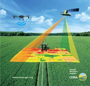
Field mapping: GIS can create detailed maps of farm fields, providing information on their size, shape, and location, as well as the distribution of crops, irrigation systems, and other features.
Crop monitoring: GIS can be used to monitor crop growth and health, providing farmers with valuable information on which crops are performing well, and which ones may need attention.
Pest and disease management: GIS can help identify areas where pests and diseases are most prevalent, allowing farmers to take proactive measures to prevent damage and spread.
Water management: GIS can help farmers manage their water resources, providing information on soil moisture levels, precipitation, and water usage.
Livestock tracking: GIS can be used to track the location and movements of livestock, allowing farmers to monitor their health and manage their grazing patterns.
Climate change impact analysis: GIS can be used to study the impact of climate change on agriculture, including changes in temperature, precipitation, and the frequency and severity of extreme weather events.
Overall, GIS has revolutionized the way farmers and agribusinesses manage their resources, allowing them to make informed decisions, increase productivity, and ensure the long-term sustainability of their operations.


