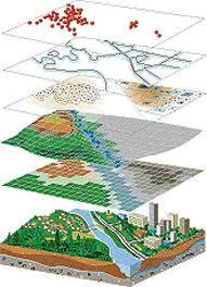
What is GIS?
Geographic Information Systems (GIS) store, analyze, and visualize data for geographic positions on Earth’s surface.
GIS stands for Geographic Information Systems and is a computer-based tool that examines spatial relationships, patterns, and trends in geography.
It was used back in 1854 (without computers of course!) to map a disease outbreak in the City of London. Fundamentally, we still use this type of spatial analysis today but in a more sophisticated way.
What is GIS Mapping?
GIS mapping produces visualizations of geospatial information. The 4 main ideas of Geographic Information Systems (GIS) are:
Because viewing and analyzing data on maps impacts our understanding of data, we can make better decisions using GIS.
It helps us understand what is where. The analysis becomes simple. Answers become clear.
Because you don’t fully understand your data until you see how it relates to other things in a geographic context.
What are the Use Cases of GIS?
Every day, GIS powers millions of decisions around the world. It makes a big impact on our lives and you might not even realize it. For example, we use GIS for:
These 1000 GIS applications illustrate all the potential use cases of Geographic Information Systems.